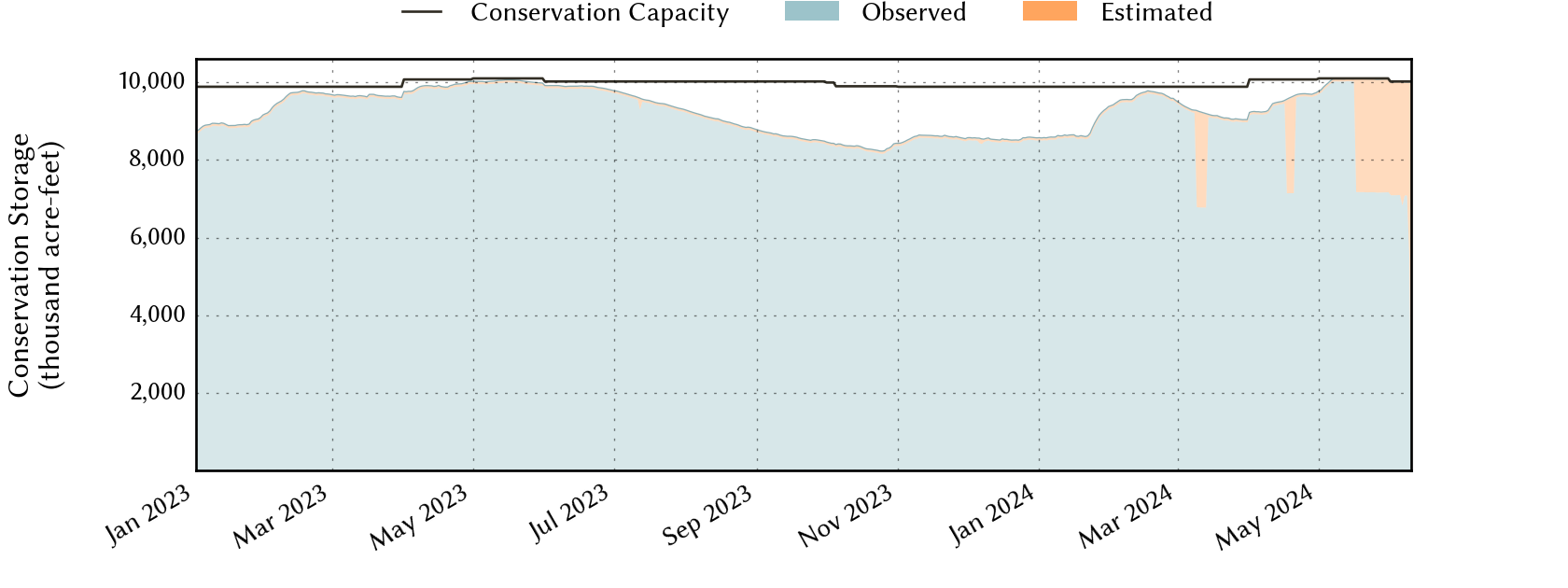
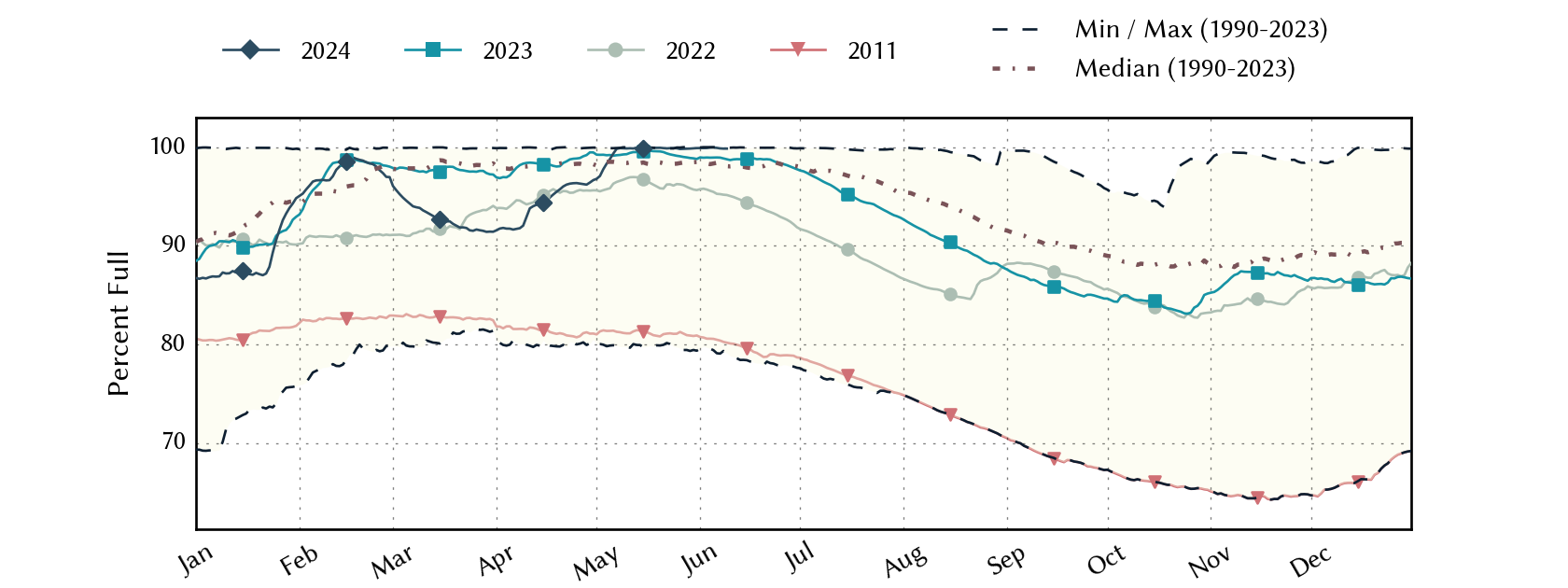
East-Texas Climate Division Reservoirs: Monitored Water Supply Reservoirs are 99.9% full on 2024-05-13
Historical Data
| Date | Percent Full |
Reservoir Storage (acre-ft) |
Conservation Storage (acre-ft) |
Conservation Capacity (acre-ft) |
|
|---|---|---|---|---|---|
| Today | 2024-05-13 | 99.9 | 12,964,637 | 10,087,001 | 10,101,935 |
| Yesterday | 2024-05-12 | 99.9 | 12,958,558 | 10,087,026 | 10,101,935 |
| 2 days ago | 2024-05-11 | 99.9 | 12,956,967 | 10,089,172 | 10,101,935 |
| 1 week ago | 2024-05-06 | 99.3 | 13,069,190 | 10,033,348 | 10,101,935 |
| 1 month ago | 2024-04-13 | 94.1 | 12,583,487 | 9,483,800 | 10,074,732 |
| 3 months ago | 2024-02-13 | 98.0 | 12,472,845 | 9,691,776 | 9,886,943 |
| 6 months ago | 2023-11-13 | 87.3 | 10,828,170 | 8,628,830 | 9,886,943 |
| 1 year ago | 2023-05-13 | 99.5 | 12,777,985 | 10,049,111 | 10,101,935 |
*
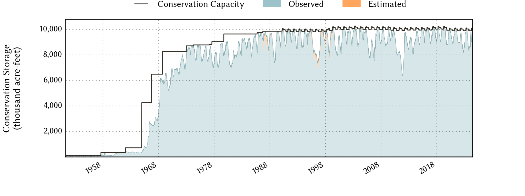
Percent Full is based on Conservation Storage and Conservation Capacity and doesn't account for storage in flood pool.
Area Map

Reservoir Storage
| Reservoir | Percent Full |
Water Level (ft) |
Height Above Conservation Pool (ft) |
Reservoir Storage (acre-ft) |
Conservation Storage (acre-ft) |
Conservation Capacity (acre-ft) |
Surface Area (acres) |
|---|---|---|---|---|---|---|---|
| Athens | 100.0 | 440.61 | 0.61 | 30,694 | 29,503 | 29,503 | - n.a. - |
| B A Steinhagen | 88.3 | 82.18 | -0.82 | 61,177 | 61,104 | 69,186 | 9,480 |
| Bob Sandlin | 100.0 | 337.95 | 0.45 | 207,167 | 192,417 | 192,417 | - n.a. - |
| Caddo 1 | 100.0 | 170.03 | 1.53 | 169,817 | 29,898 | 29,898 | 30,144 |
| Cedar Creek | 100.0 | 322.12 | 0.12 | 648,718 | 644,686 | 644,686 | - n.a. - |
| Cherokee | 100.0 | 280.43 | 0.43 | 46,547 | 40,094 | 40,094 | - n.a. - |
| Conroe | 100.0 | 201.25 | 0.25 | 423,257 | 417,577 | 417,577 | 20,585 |
| Cypress Springs | 100.0 | 378.94 | 0.94 | 69,827 | 66,756 | 66,756 | - n.a. - |
| Fork | 100.0 | 403.51 | 0.51 | 650,154 | 605,061 | 605,061 | - n.a. - |
| Gibbons Creek | 93.8 | 246.37 | -0.63 | 25,838 | 24,134 | 25,721 | 2,485 |
| Houston County | 100.0 | 261.17 | 1.17 | 19,208 | 17,113 | 17,113 | - n.a. - |
| Jacksonville | 100.0 | 422.27 | 0.27 | 26,046 | 25,670 | 25,670 | - n.a. - |
| Lake O' the Pines | 100.0 | 234.60 | 4.60 | 361,389 | 268,566 | 268,566 | - n.a. - |
| Livingston | 100.0 | 131.24 | 0.24 | 1,622,299 | 1,603,504 | 1,603,504 | - n.a. - |
| Martin | 100.0 | 306.08 | 0.08 | 76,123 | 75,726 | 75,726 | - n.a. - |
| Monticello | 87.6 | 337.78 | -2.22 | 30,430 | 30,430 | 34,740 | 1,800 |
| Murvaul | 100.0 | 265.70 | 0.40 | 39,667 | 38,285 | 38,285 | - n.a. - |
| Nacogdoches | 100.0 | 279.37 | 0.37 | 40,338 | 39,522 | 39,522 | - n.a. - |
| Palestine | 100.0 | 345.88 | 0.88 | 387,998 | 367,303 | 367,303 | - n.a. - |
| Sam Rayburn | 100.0 | 165.51 | 1.11 | 3,002,054 | 2,857,077 | 2,857,077 | - n.a. - |
| Striker | 97.7 | 292.80 | -0.20 | 21,410 | 16,488 | 16,878 | 1,939 |
| Sulphur Springs | 96.8 | 458.64 | -0.31 | 17,182 | 17,182 | 17,747 | - n.a. - |
| Toledo Bend 2 | 100.0 | 172.24 | 0.24 | 4,533,474 | 2,236,450 | 2,236,450 | 183,651 |
| Tyler | 100.0 | 375.67 | 0.29 | 78,662 | 72,073 | 72,073 | - n.a. - |
| Wright Patman | 100.0 | 229.31 | 1.81 | 375,161 | 310,382 | 310,382 | - n.a. - |
footnotes
1
Caddo Lake straddles the border of Texas and Louisiana, Texas has rights to 50% of Lake Caddo's total conservation capacity. Percent full, conservation storage and conservation capacity are based on the Texas share.
2
Toledo Bend Reservoir straddles the border of Texas and Louisiana, Texas has rights to 50% of Toledo Bend Reservoir's total conservation capacity. Percent full, conservation storage and conservation capacity are based on the Texas share.